Tuesday, June 26, 2012

Email from Lynn - 6/26/2012

Here are photos from the Sacred Grove.  

We saw this boy reading and 
asked if we could take his picture.  

A minute later we passed his parents on the path and a woman said, "Hello Haskell's".  
It was Janet Allen.  
The Allen's lived next to us when David & Alma were born, and we have been close to the parents since.  

In fact we served with them at the MTC Mission, as we recommended them to be called to serve there.  I taught Janet at American Fork.

June 2012 - more photos

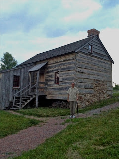
The Log Cabin, on the 
Joseph Smith Farm,
 and next to 
the Sacred Grove.


The last two photos show the sign to the visitors center and the rest of the pictures were taken from the sign looking up Stafford Road 
where we live.


Our home is just a couple of blocks up the road or about where the car is in the last picture.  

So we are really close. 
We just walk to the grove.

Monday, June 11, 2012

The Peter Whitmer Farm


Peter Whitmer Farm

In the Peter Whitmer log home, many key events in Latter Day Saint history transpired. During the six months Joseph and Emma Smith lived with the Whitmers, a good portion of the Book of Mormon was translated there. It is near this location where The Three Witnesses were shown the plates by the angel Moroni. Also, the official organization of the Church of Christ (later renamed the Church of Jesus Christ of Latter Day Saints in 1838) is said to have taken place here on April 6, 1830.

Peter Whitmer, Sr., his wife Mary Musselman Whitmer, and their eight children, Christian, Jacob, John, David, Catherine, Peter Jr., Nancy and Elizabeth Ann resided here.


The White House

Here a few photos of the apartment that Elder & Sister Haskell stay in.   They will be moving form 968 to across the street to the White House tomorrow.  The address will remain the same for mail purposes however.  
They will be in the two story portion of the White House.


Friday, June 8, 2012

The Erie Canal

Erie Canal - Palmyra
PALMYRA, NY - ERIE CANAL
The Erie Canal is a man-made waterway in New York that runs about 363 miles from Albany on the Hudson River to Buffalo at Lake Erie, completing a navigable water route from the Atlantic Ocean to the Great Lakes. It was under construction from 1817 to 1825. The Erie Canal Boat Lock Park is a great American historical site.


Wednesday, June 6, 2012

A Grove, A Hill and A Farm


The Smith Family Farm was the boyhood home of Joseph Smith, Jr., the founder of the Latter Day Saint movement.


The farm—located in the townships of Palmyra, Wayne County and Manchester, Ontario County, New York—includes the Sacred Grove, the Smiths' restored frame home and a reconstructed log home.  


The farm site passed into ownership of 
The Church of Jesus Christ of Latter-day Saints (LDS Church) in 1916, and in the 1990s, the church restored the frame home, reconstructed the log home, and built a welcome center. Church missionaries provide free tours.


The foundational event of the Latter Day Saint movement took place in what is commonly referred to as The Sacred Grove. This Grove is a forested area near the border of western New Yorknear the home of Joseph Smith, Jr.. It is the location where Smith had his First Vision, an important theophany in the movement's theology occurring in the Spring of the year 1820.

The exact location of the Sacred Grove is not known, but it would have been west of Smith's adolescent home on the border of the towns of Palmyra and Manchester. This area was being cleared at the time for farming by the Smith family, who were also using the trees to harvest maple syrup. The area has been purchased by The Church of Jesus Christ of Latter-day Saints, who cares for the area and allows tourists to visit. Latter Day Saints view the place as a sacred site.


Cumorah (play /kəˈmɔr.ə) (also known as Mormon Hill, or Gold Bible Hill, and Inspiration Point)  is a drumlin inManchester, New York, where Joseph Smith, Jr. said he found a set of gold plates which he translated into English and published as theBook of Mormon.
In the text of the Book of Mormon, "Cumorah" is a hill located in a land of the same name, which is "a land of many waters, rivers and fountains".  In this hill Book of Mormon figure Mormon deposited a number of metal plates containing the record of his nation of Nephites, just prior to their final battle with the Lamanites in which at least 230,000 people were killed.
Early Latter Day Saints assumed that the Cumorah in New York was the same Cumorah described in the Book of Mormon, but in the early-20th century, scholars from the Reorganized Church of Jesus Christ of Latter Day Saints (RLDS Church) and The Church of Jesus Christ of Latter-day Saints (LDS Church) began to speculate that there were two such hills and that final battle in the Book of Mormon took place on a hill in southern Mexico, Central America, or South America. The LDS Church has no official position on the matter[11] and these hypotheses are not held by some leaders and members of the LDS Church but firmly espoused by others.

Saturday, June 2, 2012

Let Us Introduce Ourselves

This write up was done for a Palmyra Couples information booklet.